.png)


Tywi Valley Through Time

From Ancient Oceans to Royal Strongholds
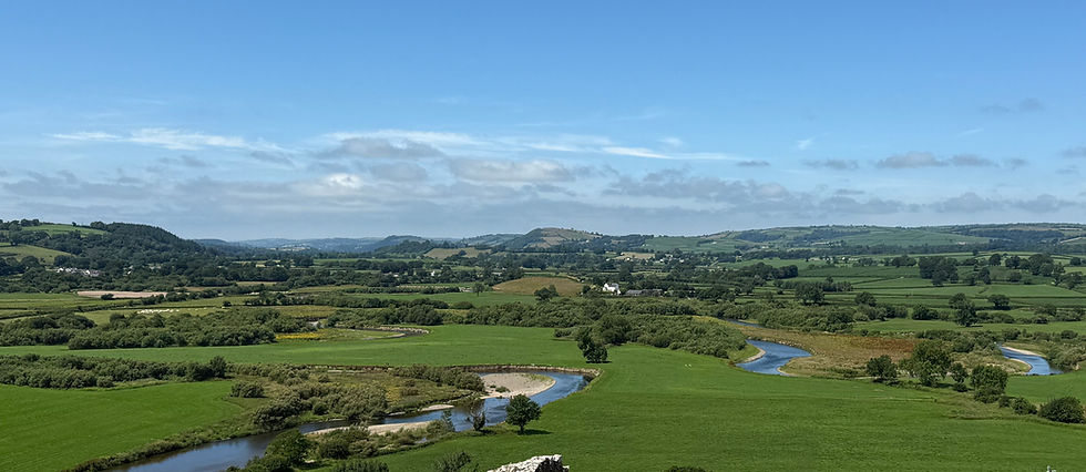
Stretching from the Cambrian Mountains to Carmarthen Bay, the Tywi Valley is one of Wales' most remarkable historic landscapes. Today it is renowned for its rolling countryside, ancient woodlands, medieval castles and thriving market towns, yet every hill, river and monument tells part of a story that began almost 470 million years ago.
Beneath its fields lie the remains of deep tropical seas, powerful mountain-building events and repeated Ice Ages that created the broad, fertile valley seen today. Those natural foundations attracted the first hunter-gatherers, early farmers, Iron Age communities, Roman engineers, Welsh princes and later country estates, each leaving their own mark upon the landscape.
This article follows the Tywi Valley through six distinct chapters, tracing its journey from ancient geology to the modern age. By exploring how natural processes created the landscape before successive generations adapted, defended and reshaped it, we can understand why the valley became the political heart of Deheubarth, one of Wales' richest agricultural regions and, ultimately, one of the country's best-preserved historic landscapes. Few places in Wales preserve such an unbroken story of both nature and people, making the Tywi Valley an extraordinary window into the history of the nation itself.

Nature Shapes the Valley
Around 470 million years ago, the Tywi Valley lay beneath the deep waters of the Welsh Basin, where fine mud and silt accumulated on the seabed over millions of years. Periodically, volcanic eruptions from an active volcanic arc elsewhere in Wales sent vast clouds of ash drifting across the basin, where they settled through the seawater to form layers that were later transformed into volcanic tuffs.
As ancient continents collided during the Caledonian Orogeny, these rocks were compressed, folded and faulted, raising the mountains that would eventually become Eryri. The immense heat and pressure transformed many of the mudstones into slate, while mineral-rich fluids deposited veins of copper, lead and other metals within fractures in the rock. These natural resources would shape the region's future just as much as its mountains.
The landscape seen today, however, owes as much to ice as it does to fire. During the last Ice Age, vast glaciers flowed through the mountains, widening existing valleys and carving dramatic new landforms. They created the broad U-shaped valleys of Llanberis and Nant Gwynant, hollowed out corries such as Cwm Idwal, sharpened the narrow ridge of Crib Goch, and left behind the countless lakes that still fill the mountain hollows.
As the ice retreated around 12,000 years ago, rivers such as the Glaslyn and Ogwen continued to shape the landscape, while peat slowly developed across the uplands. Grasses, shrubs and eventually woodlands spread across the valleys, providing habitats for wildlife that migrated into Wales as the climate warmed. Red deer, wild boar, wolves and brown bears roamed the forests, while rare Arctic-alpine plants, including the Snowdon lily and purple saxifrage, survived on the highest slopes. Peregrine falcons nested among the cliffs, and choughs foraged across the windswept mountainsides.

The First People of the Valley
As the climate warmed following the end of the last Ice Age, the first people began exploring the Tywi Valley during the Mesolithic period. These mobile hunter-gatherers left few permanent traces, so the archaeological evidence is relatively scarce. Nevertheless, worked flint scatters discovered during fieldwalking and excavation, together with evidence from Cwmifor west of Llandeilo, show that people repeatedly returned to the valley as woodland spread across the landscape. The River Tywi and its floodplain provided an abundance of resources, including salmon, trout and waterfowl, while the surrounding forests supplied deer, wild boar, berries and hazelnuts. Fresh water, plentiful food and the valley's natural route through southwest Wales made it an attractive place for seasonal occupation long before permanent settlements were established.
Around 4000 BC, the introduction of farming transformed both the landscape and the lives of its inhabitants. The archaeological evidence becomes much stronger during the Neolithic, particularly at Cwmifor, where excavations have revealed numerous pits, postholes, charcoal, burnt bone and worked flints, indicating an extensive farming settlement rather than isolated activity. Several polished stone axes have also been discovered, including examples from Dinefwr and Cae Crug Mawr. While these were practical tools used to clear woodland for cultivation, they also carried prestige, reflecting the growing importance of land ownership and status. The chambered tomb near Bethlehem, close to Llangadog, provides further evidence of settled communities. Built through considerable communal effort, it served as a collective burial monument, demonstrating that the valley's first farmers had established permanent homes and developed enduring connections with particular places. Fertile alluvial soils, easily cultivated river terraces, reliable water supplies, woodland for timber and fuel, and grazing on the surrounding hills combined to make the Tywi Valley one of the most favourable environments for early agriculture in southwest Wales.
During the Bronze Age, farming expanded further as communities cleared woodland, grazed livestock, cultivated small fields and deliberately maintained open ground through controlled burning. The archaeological emphasis shifted away from settlements towards monuments honouring the dead. Round barrows and cairns were constructed on prominent hills overlooking the valley, creating ceremonial landscapes that remained visible for generations. Sites such as Trichrug, Tair Cairn Isaf and Tair Cairn Uchaf dominate the surrounding ridges, while the possible round barrow at Cae Crug Mawr overlooks the fertile floodplain. A quartzite hammerhead discovered beneath Dinefwr Castle provides additional evidence that Bronze Age communities were active throughout the valley. Together, these monuments suggest that while people lived and farmed on the valley floor, they chose the surrounding hills to commemorate their ancestors and define their relationship with the landscape.
By the Iron Age, the Tywi Valley had become a well-organised agricultural landscape occupied by permanent farming communities. Wheat, barley and oats were cultivated on the fertile floodplain, while cattle, sheep and pigs grazed the surrounding hills. Defended settlements occupied commanding positions overlooking this productive landscape, allowing their inhabitants to monitor movement along the valley, protect livestock and display their authority. Hillforts such as Trichrug and Pen-y-Gaer formed part of this network, but the greatest was Garn Goch, the largest Iron Age hillfort complex in southern Wales. Comprising the neighbouring forts of Y Gaer Fawr and Y Gaer Fach, its massive stone ramparts enclosed numerous roundhouses, livestock pens, grain stores, workshops and communal spaces. Rather than serving solely as a fortress, Garn Goch was probably a regional centre where people gathered for trade, feasting, political meetings and refuge during times of conflict. Occupied by communities associated with the Demetae tribe, the Tywi Valley had become a settled, defended and carefully managed landscape long before the arrival of the Romans.

Romans, Saints and Welsh Kingdoms
The Roman conquest brought profound change to the Tywi Valley, not through the creation of large towns, but through the exploitation of one of Britain's richest natural resources. Around AD 74–78, the Romans established the gold mines at Dolaucothi in the nearby Cothi Valley, where open-cast workings, underground tunnels, aqueducts, reservoirs and water-powered ore-crushing technology extracted gold from the hillsides. An auxiliary fort at nearby Luentinum protected the mines, while roads including Sarn Helen linked the complex with Llandovery, Llanio and the civitas capital at Moridunum. Elsewhere in the valley, scattered Roman coins, pottery and brooches show that farming communities remained occupied and connected to the wider Roman economy, supplying grain, cattle and sheep rather than developing into heavily urbanised settlements.
Following the end of Roman rule, political and religious power shifted from forts and engineering towards native kingdoms and the Christian Church. Dinefwr emerged as the royal centre of Ystrad Tywi, and later Deheubarth, where timber halls, workshops and livestock enclosures formed the Welsh royal court, or llys, long before the construction of the medieval castle. At the same time, Christianity spread rapidly across the valley. St Teilo's Church at Llandeilo stands on the site of a sixth-century clas traditionally founded by Saint Teilo, with carved stone cross fragments confirming its importance as an early Christian centre that later became one of Wales' leading ecclesiastical sites. Nearby, Llangadog preserves the characteristic layout of an early church enclosure surrounded by radial field systems, showing how churches became centres of worship, education and estate management. Llandyfeisant Church, dedicated to Saint Tyfei, is also thought to have early medieval origins. Although no sixth-century remains have been excavated, its irregular churchyard, dedication to an early Welsh saint and location beside Dinefwr strongly suggest it began as an early Christian foundation serving both the surrounding farming communities and the nearby royal court.
Although few settlements survive from this period, archaeology suggests that most people lived in scattered timber farmsteads, organised into irregular, sprawling trefi which spread across the landscape, instead of in the tightly packed villages and towns of later periods. Farming continued across the fertile floodplain while native kingdoms emerged, Dinefwr became the political heart of the valley and Llandeilo its principal religious centre. Rather than a period of decline, the centuries after Rome transformed the Tywi Valley into the heartland of an emerging Welsh kingdom, where royal authority and Christianity together shaped the landscape that would define the medieval age.

The Heartland of Deheubarth
During the medieval period, the Tywi Valley became the political, economic and religious heartland of the Welsh kingdom of Deheubarth. Its fertile floodplain supported a prosperous agricultural economy, while control of the valley's river crossings and routeways made it one of the most strategically important regions in southwest Wales. Castles, churches, monasteries and planned towns emerged across the landscape, transforming the valley into a centre of Welsh royal authority.
Dinefwr Castle became the principal seat of the princes of Deheubarth during the early thirteenth century. Perched above the River Tywi, its curtain walls, great round keep, gatehouses and domestic buildings dominated the surrounding floodplain, serving as both a formidable fortress and a powerful symbol of Welsh independence. Further downstream, Dryslwyn Castle guarded another important crossing of the Tywi. Excavations have uncovered its round tower, great hall, kitchens, chapel, prison and extensive outer wards, together with the remains of a planned borough beneath the castle. Streets, house platforms, property boundaries and everyday artefacts provide one of the clearest pictures of daily life around a native Welsh castle anywhere in Wales.
To the west, Carreg Cennen occupied one of the most dramatic defensive positions in Wales. Although much of the surviving masonry dates from Edward I's conquest, the first castle was almost certainly built by the princes of Deheubarth during the late twelfth century to control the upper Tywi Valley and the approaches from the Black Mountain. Built upon an isolated limestone crag above a natural cave, it demonstrates how geology influenced medieval warfare by providing sheer natural defences, abundant building stone and commanding views across the surrounding countryside. Together, Dinefwr, Dryslwyn and Carreg Cennen illustrate how the Tywi Valley became the political and military heart of medieval southwest Wales before passing into English control after the conquest of 1282.
Religion remained equally important. Founded around 1185 by Rhys ap Gruffydd, Talley Abbey became one of the principal monastic houses of southwest Wales, managing extensive estates, fisheries and farmland. St Teilo's Church at Llandeilo continued to serve the growing town that had developed around its early Christian foundation, while nearby Llandyfeisant Church reflected the close relationship between the princes of Deheubarth and the Church within the Dinefwr estate. Throughout the valley, medieval field systems, mill sites, fish ponds, drove routes and surviving boundaries reveal how intensively the fertile floodplain was farmed and managed.

From Castles to Country Estates
The conquest of Wales by Edward I marked the end of native princely rule in the Tywi Valley, but it did not bring an end to the communities that had flourished there for centuries. During the fifteenth century, Dinefwr Castle remained occupied by the descendants of the Lord Rhys before eventually passing into the hands of the Rice family. Although relatively little archaeological evidence survives from this period, this is largely because settlements, churches and farmsteads continued to be occupied rather than abandoned or rebuilt. The fertile floodplain remained one of southwest Wales' most productive agricultural landscapes, supporting prosperous farming communities under the growing influence of the Welsh gentry.
The valley also witnessed the final attempt to restore an independent Welsh principality. During the Glyndŵr Rising (1400–1415), Carmarthenshire largely supported Owain Glyndŵr's revolt against English rule, and Dinefwr Castle became associated with his campaign before eventually returning to English control. Although few identifiable archaeological remains of the uprising survive within the valley, the conflict marked the last major military challenge to English authority in Wales.
The Acts of Union of 1535 and 1542 transformed Wales once again by fully integrating it into the English legal system. As peace became more secure, castles such as Dinefwr, Dryslwyn and Carreg Cennen rapidly lost their military importance. Wealth and influence were no longer demonstrated through defensive fortifications but through the ownership of land, agricultural improvement and the creation of prestigious country estates.
This changing society is best illustrated at Dinefwr. In 1660, the Rice family built Newton House over the medieval borough of Newtown, replacing the castle as the family's principal residence. Excavations have uncovered the buried streets, burgage plots and house foundations of the lost medieval town beneath the estate, demonstrating continuity of occupation despite the dramatic change in landscape. During the seventeenth and eighteenth centuries, the estate was transformed into one of Wales' finest designed landscapes, with deer parks, carriage drives, ornamental lakes, plantations and carefully framed views, much of it later redesigned by Lancelot 'Capability' Brown. Across the valley, estates such as Aberglasney and Golden Grove developed walled gardens, terraces, stables and productive estate farms, while new field boundaries, drainage systems, bridges and roads reshaped the countryside. Together, these changes marked the Tywi Valley's transition from a medieval landscape of castles and royal power to one defined by country houses, designed estates and agricultural prosperity.

An Agricultural Industrial Revolution
The Industrial Revolution transformed the Tywi Valley, but in a very different way from the coalfields and ironworks of South Wales. Rather than becoming a centre of heavy industry, the valley built upon its long-established agricultural economy. Llandeilo developed into the commercial hub of the middle Tywi Valley, where flour mills, woollen mills, sawmills, tanneries, warehouses and markets processed produce from the surrounding countryside instead of coal and iron.
Improved transport revolutionised trade. The arrival of the railway in the nineteenth century brought stone cuttings, embankments, tunnels, station buildings and iron bridges, including the surviving lattice railway bridge at Llandeilo, completed in 1852. These new transport links allowed livestock, timber, wool, lime and agricultural produce to reach wider markets more efficiently, strengthening the valley's rural economy. At the same time, numerous lime kilns burned locally quarried limestone to produce agricultural lime for improving acidic soils and lime mortar for construction, while watermills powered by streams flowing into the River Tywi continued to grind grain, saw timber and process local produce.
The valley's great estates also embraced agricultural improvement. Dinefwr, Golden Grove and Aberglasney invested in estate sawmills, workshops, bridges, roads, drainage systems and model farms, increasing productivity rather than encouraging large-scale manufacturing. Only in the upper Tywi Valley did industry dominate the landscape, where the Nantymwyn Lead Mine at Rhandirmwyn expanded into one of the largest lead mines in Wales, leaving behind engine houses, mine shafts, spoil tips, dressing floors, tramways and workers' housing. Unlike Merthyr Tydfil or Swansea, however, the Tywi Valley never became a landscape of coal mines, ironworks or steelworks. Its fertile soils remained more valuable than heavy industry, preserving the rural character that still defines much of the valley today.
Today, the Tywi Valley is far more than a beautiful Welsh landscape. Its rocks, rivers, monuments, churches, castles, estates and industries preserve an almost continuous record of 470 million years of natural and human history. Each generation inherited the work of those before it, adapting the valley to meet new challenges while leaving its own mark upon the landscape. By exploring the Tywi Valley through time, we discover not only how this remarkable place was shaped, but how Wales itself has evolved through the ages.
Enjoyed this article?
This is just one chapter in the wider story of Wales. Explore the six Cymru Cycles to discover how geology, archaeology, history and industry together shaped the nation we see today.
Learn More About Wales Through Time
Choose a Cycle Below


Comments