.png)


The Ancient Cymru Cycle explores the peoples, beliefs, traditions, and landscapes of prehistoric and early Wales.
Through the stories of the Celts, ancient religion, and the landscapes that inspired them, it examines how communities understood the world around them and developed the foundations of Welsh culture.
Building upon the natural world explored in the Natural Cymru Cycle, it shows how people interacted with the land and transformed it into a landscape of meaning, memory, and identity.
The cycles that follow continue this story, tracing how these early traditions influenced the kingdoms, communities, culture, and society that emerged across later ages of Welsh history.


From hillforts rising above the valleys to roundhouses clustered beside rivers and forests, Celts of Cymru explores the lives, societies, and landscapes of Iron Age Wales before the arrival of Rome. Rather than focusing only on warfare and legend, the book examines how the Celtic peoples of Cymru lived, traded, farmed, travelled, worshipped, and organised their communities across a changing landscape.

From sacred lakes and mountain peaks to hearth fires, forests, and ancient ritual sites, Divinity of Cymru explores the religious world, cosmology, and spiritual ideas of ancient Wales. Drawing upon mythology, archaeology, folklore, linguistics, and comparative Celtic belief, the book reconstructs how the peoples of Cymru understood existence, nature, memory, death, and the unseen forces believed to shape the world around them.

From mist-covered lakes and sacred rivers to mountain passes, caves, forests, and standing stones, Landscapes of Cymru explores the mythic and spiritual geography of ancient Wales. Blending mythology, archaeology, folklore, and landscape interpretation, the book examines how the peoples of Cymru understood the natural world through thresholds, memory, and the unseen forces believed to exist within the land itself.


As the climate warmed after the last Ice Age, forests spread across Eryri and the first hunter-gatherers followed herds of wild animals into its valleys, leaving behind small flint tools and seasonal camps. Around 6,000 years ago, farming reached the surrounding lowlands, where forests were cleared, fields created and chambered tombs built to honour ancestors. During the Bronze Age, burial cairns, standing stones and roundhouses appeared across the landscape, while the Iron Age saw permanent farming settlements and hillforts guarding key routes. Together, these remains reveal Eryri becoming both a homeland and a sacred landscape.

The First People of the Mountains
1st July 2026
The First People of the Valley
11th July 2026
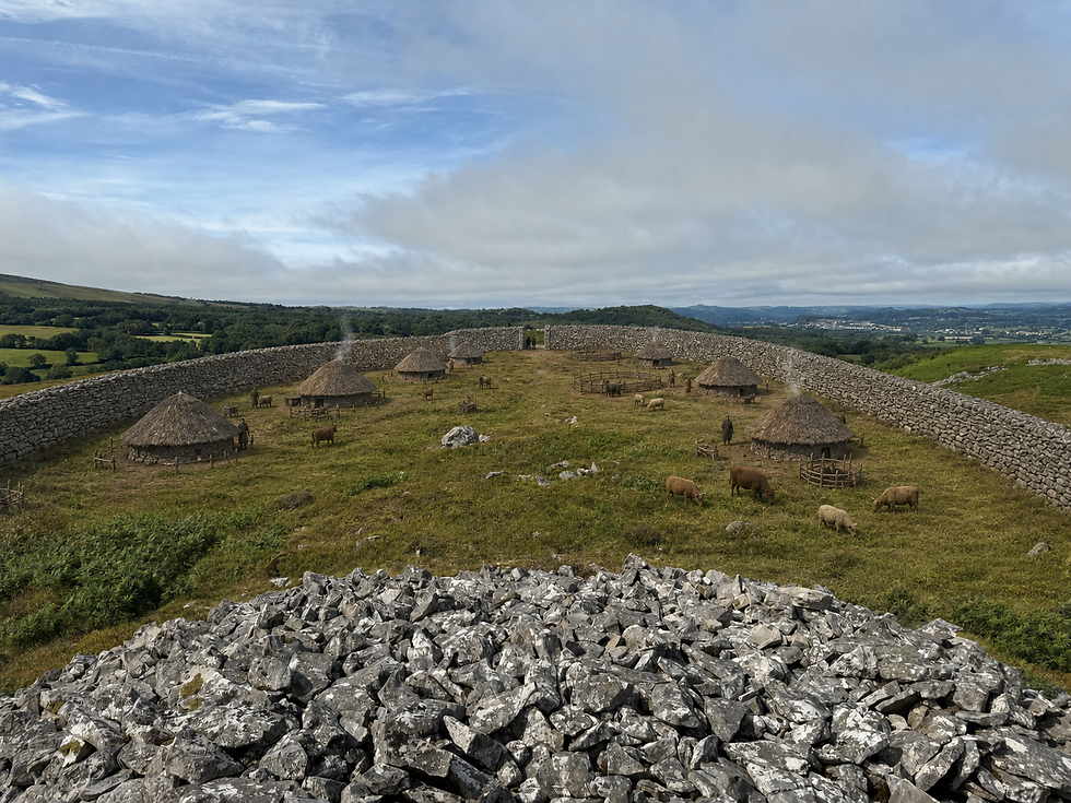
The fertile Tywi Valley offered one of the best places in southwest Wales for people to settle. Early hunter-gatherers were drawn by its river, woodlands and abundant wildlife before farming communities established permanent settlements on its rich floodplain. As agriculture expanded, chambered tombs, burial cairns and round barrows reflected growing connections to the land and to ancestors. By the Iron Age, productive farms and powerful hillforts such as Garn Goch overlooked a carefully managed landscape, revealing a valley that had become both a prosperous farming heartland and an important regional centre.

COMING SOON!
Journal highlighting the most recent research happening in Cymru



Explore ancient features including capel garmon chambered tomb.

Explore ancient features including waun pwllyn long barrow, garn goch hillfort and trichrud hillfort.

Coflein is the online database of the Royal Commission on the Ancient and Historical Monuments of Wales. It contains records for more than one hundred thousand archaeological sites, historic buildings and landscapes across Wales, making it one of the most valuable resources for exploring prehistoric archaeology.
Each record may include photographs, excavation reports, historic maps, aerial photographs, references to published research and links to nearby archaeological sites. While the amount of information varies from site to site, Coflein allows you to investigate far more monuments than those managed by Cadw.
How to search for prehistoric archaeology
-
Open the Coflein website.
-
Select Advanced Search. Although the basic search is useful if you already know the name of a site, the advanced search provides much greater control when exploring a particular archaeological period.
-
Under Period, select the period you wish to investigate. Useful examples include:
-
Mesolithic
-
Neolithic
-
Bronze Age
-
Iron Age
-
-
Under Monument Type, select the kind of site you are interested in. Examples include:
-
Chambered Tomb
-
Standing Stone
-
Stone Circle
-
Burial Cairn
-
Hillfort
-
Promontory Fort
-
Roundhouse
-
Hut Circle
-
Burnt Mound
-
Hill Slope Enclosure
-
-
If you are interested in a particular part of Wales, enter a county, town or place name, or use the interactive map to narrow your search area.
-
Browse the search results and open individual monument records.
-
Within each record, examine:
-
photographs;
-
aerial imagery;
-
location maps;
-
archaeological descriptions;
-
references to excavations;
-
published sources.
-
-
Use the interactive map to identify nearby prehistoric sites. Many monuments survive as part of wider prehistoric landscapes rather than in isolation.
Understanding the results
Not every Coflein record contains the same level of detail. Some sites have been extensively excavated and researched, while others are known only from aerial photography, geophysical surveys or brief field observations.
The archaeological description usually explains:
-
what survives today;
-
when the monument was built;
-
how archaeologists interpret the site;
-
whether excavations have taken place;
-
and how confident researchers are about its date or function.
Many records also contain an NPRN (National Primary Record Number). This is simply the unique identification number assigned to that monument within the Coflein database and is useful when searching for further information in archaeological publications.
If you encounter unfamiliar terminology, remember that many archaeological site types have more than one accepted name. For example, a chambered tomb may also be described as a megalithic tomb, portal dolmen or Neolithic burial monument, depending on its form and the publication being consulted.
Coflein is particularly powerful when exploring landscapes rather than individual monuments. After finding one site, examine the surrounding area to discover nearby standing stones, cairns, field systems or hillforts that together reveal how prehistoric communities used the landscape.

While Coflein aims to record every known archaeological site in Wales, Cadw focuses on protecting and interpreting the nation's most significant prehistoric monuments. Its website provides historical background, visitor information and interpretation for many of the best-preserved sites in Wales, making it an ideal companion to the archaeological records found within Coflein.
Cadw is particularly useful when planning visits. Its monument pages explain why a site is important, how it fits into Welsh prehistory and what features visitors should look for when exploring it. Many entries also include reconstruction illustrations, photographs and downloadable guides that help bring the archaeology to life.
How to explore prehistoric monuments
-
Open the Cadw History Map.
-
Enter the name of a town, village or area of Wales that you would like to explore. Alternatively, zoom directly into the interactive map.
-
Filter the results to display Prehistoric monuments. Depending on the area you are exploring, this may include:
-
chambered tombs;
-
standing stones;
-
stone circles;
-
burial cairns;
-
hillforts;
-
prehistoric settlements;
-
defended enclosures.
-
-
Select a monument from the map to open its information page.
-
Begin by reading the historical overview. This usually explains:
-
when the monument was built;
-
who built it;
-
its original purpose;
-
how archaeologists interpret the site today.
-
-
Study the photographs and illustrations carefully before visiting. These often highlight archaeological features that are easily overlooked when viewed on the ground.
-
Read the visitor information, including:
-
directions;
-
parking;
-
public access;
-
opening arrangements;
-
accessibility;
-
nearby Cadw sites.
-
-
Explore the surrounding area using the History Map. Many prehistoric monuments survive within larger archaeological landscapes containing several related sites. Visiting multiple monuments in the same area often provides a much clearer understanding of how prehistoric communities used the landscape.
Understanding the results
Unlike Coflein, Cadw does not attempt to record every archaeological site in Wales. Instead, it concentrates on monuments that are considered nationally important and are often protected as Scheduled Monuments.
Because of this, the information is generally written for a wider audience and focuses on explaining the significance of a site rather than providing detailed archaeological records. This makes Cadw an excellent place to begin if you are unfamiliar with a monument or are planning your first visit.
Many monument pages also include interpretation drawings or artistic reconstructions. These are particularly valuable for prehistoric sites where little survives above ground today. A low grass-covered mound or an earthwork may once have been an impressive tomb, ceremonial monument or defended settlement, and the reconstructions help visitors visualise how these places originally appeared.
Cadw also provides context that is often missing from archaeological databases. Rather than describing a monument in isolation, the website frequently explains how it relates to wider developments such as the introduction of farming during the Neolithic, the emergence of metalworking in the Bronze Age or the construction of defended hillforts during the Iron Age.
Archaeological sites rarely survive exactly as they appeared when they were inhabited. Timber buildings decay, thatched roofs disappear and many hillforts are now visible only as earthworks beneath grass or woodland. While excavation records can explain what archaeologists have discovered, they do not always make it easy to imagine how prehistoric communities actually lived.
Castell Henllys Iron Age Village bridges that gap. Built on the site of a genuine Iron Age hillfort in Pembrokeshire, it is the only reconstructed Iron Age village in Britain located within the original archaeological monument. The buildings have been reconstructed using evidence recovered during archaeological excavations and traditional building techniques, allowing visitors to experience an Iron Age settlement at full scale.
Rather than replacing the archaeological evidence, Castell Henllys helps visitors understand how that evidence is interpreted.
How to use Castell Henllys as an archaeological resource
-
Begin by exploring the history of Castell Henllys on its website before visiting. Learn when the hillfort was occupied, how it was excavated and why it was chosen for reconstruction.
-
Study the reconstructed roundhouses and examine how they were built. Pay particular attention to:
-
the circular timber framework;
-
wattle-and-daub walls;
-
thatched roofs;
-
central hearths;
-
storage areas;
-
entrances and internal layout.
-
-
Compare the reconstructed buildings with the archaeological evidence displayed on the site. Consider which parts are supported directly by excavation and which represent informed interpretation based upon wider archaeological research.
-
Explore the hillfort itself. Look beyond the reconstructed buildings and examine the earthwork defences, entrances and overall layout of the settlement within the surrounding landscape.
-
If possible, attend one of the site's demonstrations or educational events. Activities such as ironworking, weaving, cooking and woodworking help illustrate the technologies and skills that archaeological remains alone cannot fully explain.
Comparing Castell Henllys with other Iron Age sites
Once you have explored Castell Henllys, use Coflein or Cadw to investigate other Iron Age hillforts across Wales.
Choose sites such as:
-
Tre'r Ceiri;
-
Caerau Hillfort;
-
Pen Dinas;
-
Moel y Gaer;
-
Dinas Dinlle.
As you explore these monuments, compare them with Castell Henllys by asking:
-
How large is the hillfort?
-
How many defensive banks and ditches does it possess?
-
Where are the entrances located?
-
Are there visible traces of roundhouses?
-
Why was this particular location chosen?
-
How does the surrounding landscape compare?
Although every hillfort is different, many share common features that become much easier to recognise after visiting a reconstructed settlement.
Understanding the results
Reconstructions are not exact copies of the past. Archaeologists rarely recover every detail of a prehistoric building, and some elements must be reconstructed using evidence from similar sites elsewhere in Britain and Europe.
For this reason, it is useful to think of Castell Henllys as an interpretation based upon archaeological evidence rather than a perfect recreation of Iron Age life.
Its greatest value lies in helping visitors visualise archaeological discoveries. Circular stains in the soil become timber posts, postholes become complete roundhouses and shallow earthworks become thriving prehistoric communities. By combining excavation evidence with experimental archaeology, the site demonstrates how archaeologists transform buried remains into a picture of the past.